Interior of the Earth- NCERT Notes UPSC
Apr 19, 2022
Navigate Quickly
Sources of Information about the Interior
Direct Sources
Indirect Sources
Earthquake
Earthquake Waves
Earthquake waves are basically of two types
Propagation of the Earthquake Waves
Emergence of Shadow Waves
Types of Earthquake
Structure of the Earth
The Crust
The Mantle
The Core
Volcanoes and Volcanic Landforms
Shield Volcanoes
Composite Volcanoes
Caldera
Flood Basalt Province
Mid Oceanic Ridge Volcanoes
Volcanic Landforms
Intrusive landforms
Batholiths
Lacoliths
Lapolith
Phacolith
Sills or Sheets
Dykes
Interesting Points

Sources of Information about the Interior
Direct Sources
- Surface rock or rocks from mining: These are the most easily available solid earth material. Gold mines in South Africa are as deep as 3 - 4 km.
- Projects to penetrate deeper depths: Scientists are working on two major projects such as “Deep Ocean Drilling Project” and the “Integrated Ocean Drilling Project”. The deepest drill at Kola, in the Arctic Ocean, has so far reached a depth of 12 km.
- Volcanic eruption: It forms another source of obtaining direct information.
Indirect Sources
- Analysis of properties of matter: It indirectly provides information about the interior such as temperature and pressure increase with the increasing distance from the surface towards the interior in deeper depths.
- Meteors: These reach the earth, and their material and structure are similar to earth.
- Gravitation force (g):
- It is different at different latitudes on the surface. It is greater near the poles and less at the equator because distance from the centre at the equator is greater than poles.
- The reading of the gravity at different places is influenced by many factors such as the mass of the material, uneven distribution of mass of the material etc.
- The difference between these readings and the expected value is called gravity anomaly which give information about the distribution of mass of the material in the earth’s crust.
- Magnetic surveys: It provide information about the distribution of magnetic materials in the crustal portion.
- Seismic activity: The study of seismic waves provides a complete picture of the layered interior.
Earthquake
It is shaking of the earth. It is a natural event and is caused due to release of energy which generates waves that travel in all directions. The reasons for shaking of the earth:
- The release of energy occurs along a fault which is a sharp break in the crustal rocks.
- Rocks along a fault tend to move in opposite directions and as the overlying rock strata press them, the friction locks them together.
- Their tendency to move apart at some point of time overcomes the friction. As a result, the blocks get deformed and eventually, they slide past one another abruptly. This causes a release directly of energy, and the energy waves travel in all directions.
- Focus of an earthquake (hypocentre): It is the point where the energy is released.
- Epicentre: It is the point on the surface, nearest to the focus. It is the first one to experience the waves. It is a point above the focus.
Earthquake Waves
All-natural Earthquakes take place in the lithosphere.
- The velocity of waves changes as they travel through materials with different densities. The denser the material, the higher is the velocity.
- Reflection causes waves to rebound whereas refraction makes waves move in different directions.
Earthquake waves are basically of two types
- Body Waves: These waves are generated due to the release of energy at the focus and move in all directions travelling through the body of the earth. There are two types of body waves.
- P-waves: These move faster and are the first to arrive at the surface. These are also called ‘primary waves. They are similar to sound waves. They travel through gaseous, liquid, and solid materials.
- S-waves: These arrive at the surface with some time lag. These are called secondary waves. They can travel only through solid materials and this characteristic has helped scientists to understand the structure of the interior of the earth.
- Surface Waves: The body waves interact with the surface rocks and generate new set of waves called surface waves. These waves move along the surface. They are the last to report on seismograph. They are more destructive as they cause displacement of rocks, and hence, the collapse of structures occurs.
Propagation of the Earthquake Waves
Different types of earthquake waves travel in different manners. As they move or propagate, they cause vibration in the body of the rocks through which they pass.
- P-waves vibrate parallel to the direction of the wave which exerts pressure on the material in the direction of the propagation. Hence, it creates density differences in the material leading to stretching and squeezing of the material.
- The direction of vibrations of S-waves is perpendicular to the wave direction in the vertical plane. Hence, they create troughs and crests in the material through which they pass.
Emergence of Shadow Waves
Shadow Zone: They are zones where the waves are not reported. The study of different events reveals that for each earthquake, there exists an altogether different shadow zone.
- It was observed that seismographs located at any distance within 105° from the epicentre, recorded the arrival of both P and S-waves.
- The seismographs located beyond 145° from epicentre, record the arrival of P-waves, but not that of S-waves. Thus, a zone between 105° and 145° from epicentre was identified as the shadow zone for both the types of waves.

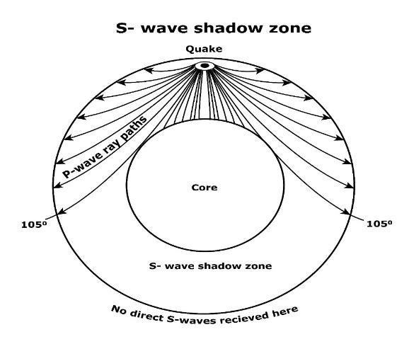
(a) and (b) Earthquake Shadow Zones
- The entire zone beyond 105° does not receive S-waves. The shadow zone of S-wave is much larger than that of the P-waves. The shadow zone of S-waves is not only larger in extent, but it is also a little over 40 per cent of the earth surface.
- The shadow zone of P-waves appears as a band around the earth between 105° and 145° away from the epicentre.
Types of Earthquake
- Tectonic Earthquake: They are most common ones and are generated due to sliding of rocks along a fault plane.
- Volcanic Earthquake: They are a special class of tectonic earthquake and these are confined to areas of active volcanoes.
- Collapse Earthquake: The roofs of underground mines collapse in the areas of intense mining activity which cause minor tremors.
- Explosion Earthquake: Ground shaking occur due to the explosion of chemical or nuclear devices.
- Reservoir induced Earthquake: These earthquakes occur in the areas of large reservoirs.
Measuring Earthquake: The earthquake events are scaled either according to the magnitude or intensity of the shock.
- Richter Scale (Magnitude Scale): The magnitude relates to the energy released during the quake. The magnitude is expressed in numbers, 0-10.
- Mercalli Scale (Intensity Scale): It is named after Mercalli, an Italian seismologist. It takes into account the visible damage caused by the event and range of intensity scale is from 1-12.
Effects of earthquake waves: Earthquake is a natural hazard therefore following effects can be seen:
| Ground Shaking | 5. Ground lurching | 9. Structural collapse |
| Differential ground settlement | 6. Avalanches | 10. Ground displacement |
| Land and mud slides | 7. Floods from dam and levee failures | 11. Fires |
| Soil liquefaction | 8. Falling objects | 12. Tsunami |
- The first six listed above have some bearings upon landforms, while others may be considered the effects causing immediate concern to the life and properties of people in the region.
- The effect of tsunami would occur only if the epicentre of the tremor is below oceanic waters and the magnitude is sufficiently high. Tsunamis are waves generated by the tremors and not an earthquake in itself.
Structure of the Earth
The Crust
- It is the outermost solid part of the earth and is brittle in nature.
- Its thickness varies under the oceanic and continental areas.
- Oceanic crust is thinner as compared to the continental crust. The mean thickness of oceanic crust is 5 km whereas that of the continental is around 30 km.
- The continental crust is thicker in the areas of major mountain systems. It is as much as 70 km thick in the Himalayan region.
The Mantle
- It is the portion of the interior beyond the crust and extends from Moho’s discontinuity to a depth of 2,900 km.
- Asthenosphere: It is the upper portion of the mantle. The word astheno means weak. It is considered to be extending up to 400 km. It is the main source of magma that finds its way to the surface during volcanic eruptions.
- Lithosphere: It is the crust and the uppermost part of the mantle and its thickness ranges from 10-200 km.
- The lower mantle extends beyond the asthenosphere and is in solid state.

The interior of the Earth
The Core
- The core mantle boundary is located at the depth of 2,900 km.
- The outer core is in liquid state while the inner core is in solid state.
- Nife layer: The core is made up of very heavy material mostly constituted by nickel and iron.
Useful links for UPSC IAS preparation:
Volcanoes and Volcanic Landforms
A volcano is a place where gases, ashes and/or molten rock material (lava) escape to the ground.
- Active Volcano: It is a volcano if the materials mentioned are being released or have been released out in the recent past.
- From asthenosphere the molten rock materials find their way to the surface. The material in the upper mantle portion is called magma. Once it starts moving towards the crust or it reaches the surface, it is referred to as lava.
- The material that reaches the ground includes lava flows, pyroclastic debris, volcanic bombs, ash and dust and gases such as nitrogen compounds, sulphur compounds and minor amounts of chlorine, hydrogen and argon.
Classification of Volcanos: Volcanoes are classified based on nature of eruption and the form developed at the surface.
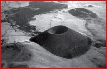
Shield Volcanoes
- Barring the basalt flows, they are the largest of all the volcanoes on the earth. For example - The Hawaiian volcanoes.
- These volcanoes are mostly made up of basalt, a type of lava that is very fluid when erupted. For this reason, these volcanoes are not steep.
- They become explosive if somehow water gets into the vent; otherwise, they are characterised by low-explosivity.
- The upcoming lava moves in the form of a fountain and throws out the cone at the top of the vent and develops into cinder cone.
Shield Volcano
Composite Volcanoes
- These volcanoes are characterised by eruptions of cooler and more viscous lavas than basalt.
- These volcanoes often result in explosive eruptions.
- Along with lava, large quantities of pyroclastic material and ashes find their way to the ground which accumulates in the vicinity of the vent openings leading to formation of layers, and this makes the mounts appear as composite volcanoes.

Composite volcano
Caldera
- These are the most explosive of the earth’s volcanoes. They are usually so explosive that when they erupt, they tend to collapse on themselves rather than building any tall structure.
- The collapsed depressions are called calderas. Their explosiveness indicates that the magma chamber supplying the lava is not only huge but is also in close vicinity.
Flood Basalt Province
- These volcanoes outpour highly fluid lava that flows for long distances.
- There can be a series of flows with some flows attaining thickness of more than 50 m. Individual flows may extend for hundreds of km.
- Deccan Traps covering most of the Maharashtra plateau are a larger flood basalt province.
Mid Oceanic Ridge Volcanoes
- These volcanoes occur in the oceanic areas.
- There is a system of mid-ocean ridges more than 70,000 km long that stretches through all the ocean basins. The central portion of this ridge experiences frequent eruptions.
Here’s a video lecture on Geostationary and Geosynchronous Earth Orbit by Sharad Tripathi Sir, our DREAM TEAM faculty for Science and Technology. Watch the video to upgrade your knowledge and your UPSC CSE preparation:
Volcanic Landforms
Intrusive landforms
- The lava that is released during volcanic eruptions on cooling develops into igneous rocks.
- The cooling may take place either on reaching the surface or within the crustal portion.
- Depending on the location of the cooling of the lava, igneous rocks are classified as volcanic rocks (cooling at the surface) and plutonic rocks (cooling in the crust).
- The lava that cools within the crustal portions assumes different forms. These forms are called intrusive forms.
Batholiths
- A large body of magmatic material that cools in the deeper depth of the crust develops in the form of large domes.
- They appear on the surface only after the denudational processes remove the overlying materials.
- They cover large areas, and at times, assume depth that may be several km.
- These are granitic bodies.
- Batholiths are the cooled portion of magma chambers.
Lacoliths
- These are large dome-shaped intrusive bodies with a level base and connected by a pipe-like conduit from below.
- It resembles the surface volcanic domes of composite volcano, only these are located at deeper depths.
- The Karnataka plateau is spotted with domal hills of granite rocks. Most of these, now exfoliated, are examples of lacoliths or batholiths.

Volcanic landforms
Lapolith
- Lava moves upwards and a portion of the same may tend to move in a horizontal direction wherever it finds a weak plane. It may get rested in different forms.
- In case it develops into a saucer shape, concave to the sky body, it is called lapolith.
Phacolith
- A wavy mass of intrusive rocks, at times, is found at the base of synclines or at the top of anticline in folded igneous country.
- Such wavy materials have a definite conduit to source beneath in the form of magma chambers (subsequently developed as batholiths). These are called the phacoliths.
Sills or Sheets
- The near horizontal bodies of the intrusive igneous rocks are called sill or sheet, depending on the thickness of the material.
- The thinner ones are called sheets while the thick horizontal deposits are called sills.
Dykes
- When the lava makes its way through cracks and the fissures developed in the land, it solidifies almost perpendicular to the ground.
- It gets cooled in the same position to develop a wall-like structure called dykes.
- These are the most commonly found intrusive forms in the western Maharashtra area. These are considered the feeders for the eruptions that led to the development of the Deccan traps.
Interesting Points
- The Earth’s radius is approximately 6,370 km.
- Lithosphere refers to the portion of depth up to 200 km from the surface of the Earth.
- The ‘seismograph’ is an instrument that records the seismic waves reaching the surface.
Download the PrepLadder app to study from India’s top UPSC faculty and transform your UPSC CSE preparation from the Beginner level to the Advanced level. You can also join our Telegram channel for UPSC coaching and to stay updated with the latest information about the UPSC exam.
Own Your Dream
Team PrepLadder
PrepLadder IAS
Get quick access to the latest happenings across the globe. Articles revolving around factual data that aims to boost your UPSC CSE preparation and make your dreams become a reality!
Top searching words
The most popular search terms used by aspirants
- Interior of the Earth NCERT Notes UPSC
- Interior of the Earth